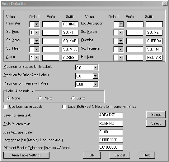
This command allows you to specify default settings for area
labeling. The top portion of the Area Defaults dialog lists ten area
values.
For
each value, you can specify a value under the Order# column, a Prefix
and a
Suffix.
The area label will include the values in the order specified. If an
Order#
is left blank, that value is not labeled. Both prefix and suffix
controls are included here, although most area labeling
uses the suffix, as in 1.25 Acres or 3.515 Hectares. But for those who
prefer a
prefix,
as in Ac: 1.25, this routine can create that area labeling style
automatically. Keep in mind that changes in
Area Defaults, if changed in the Area pulldown menu, only apply to that
work
session. If changed within the
Configure command, the changes apply to all new work sessions as well.
Sequence: The top portion of the
dialog lists ten area values.
For
each value, you can specify a value under the Order# column, a Prefix
and a
Suffix.
The area label will include the values in the order specified. If an
Order#
is left blank, that value is not labeled.
Precision for Square Units Labels: Choose precision
level for labeling Square Feet, Square Yards, Square Miles,
Square Meters, and Square Kilometers.
Precision for Other Area Labels: Choose precision level
for labeling Acres, Cuerdas, and Hectares.
Precision for Inverse with Area: Choose precision level when
using Inverse with Area.
Label Area with +/-: This allows you to display + or - in the
Prefix or Suffix of the area labels, or choose None.
Use Commas in Labels: This allows you to use commas in the
area labels.
Label Both Feet & Meters for Inverse with
Area: When this option is turned ON, both feet and meters will be
shown in the
Inverse with Area report.
Layer for area text: This allows you to assign a layer for
the area text.
Style for area text: This allows you to set a text style for
the area labels.
Area text size scaler: This value is multiplied by the
horizontal scale to obtain the actual
text size.
Max gap to join (Area by Lines and
Arcs): You use this option during
Area by Lines &
Arcs command. When connecting lines and arcs that define the
perimeter, the program will
join endpoints if the distance between the two points is less than the
specified gap. Otherwise
the program will report an error and will not report an area.
Different Radius Tolerance: You use this option to check the
difference between the
PC-Radius and PT-Radius on curves. If the difference between these
distances is greater than
this tolerance, an accurate area calculation cannot occur and the
command displays a warning. This setting is used in Inverse, Inverse
With Area, Hinged Area and Sliding Side Area.
Prefix/Suffix: Although
most area labeling uses the suffix as in 1.25 Acres or 3.515 Hectares,
those who prefer a prefix as in Ac: 1.25 can create that area labeling
style automatically. This control is shown in the dialog
below. Keep in mind that changes in Area Defaults, if changed in
the Area pulldown menu, only apply to that work session. If
changed within the Configure command, the changes apply to all new work
sessions as well.
|

|
The results of the using prefix
with square feet and acres chosen
|